The Great Rift Valley cuts through Kenya from north to south, a geological feature of such scale that astronauts have reported it visible from orbit. For pilots flying between Nairobi and the western side of the country (Kisumu, Kericho, the Masai Mara strips), the Rift Valley escarpment is both a visual landmark and a turbulence generator that demands respect and understanding.
The escarpment drops approximately 1,000 metres over a horizontal distance of a few kilometres. This abrupt terrain change, combined with Kenya's thermal cycle and prevailing wind patterns, produces turbulence that varies from mild and manageable to severe and structural-limit-testing depending on conditions.
Mechanical turbulence: what the escarpment does to airflow
Mechanical turbulence forms when moving air encounters solid terrain. The airflow is forced upward on the windward side of an obstacle and then descends and becomes turbulent on the lee side, a pattern that can extend for many times the height of the obstacle downwind.
The eastern Rift Valley escarpment, near the Naivasha area, is oriented roughly north-south. The prevailing easterly flow from the Indian Ocean hits this escarpment and is forced upward. On the valley floor to the west, the descending air creates rotors: areas of circular, unpredictable airflow that are often more severe than the surface indicated wind would suggest.
The relevant questions for any route crossing the escarpment:
- What is the surface wind direction? An easterly wind means the escarpment is windward; expect strong uplift on the eastern face and rotor activity in the valley below.
- What is the upper wind? A significant wind gradient between the surface and cruise altitude can create wave turbulence extending well above the escarpment height.
- What is the thermal activity level? In the early afternoon, thermal uplift adds to mechanically-generated turbulence, and the two together can produce severe conditions even when each individually would be manageable.
Thermal turbulence over the valley floor
The Rift Valley floor, particularly in the areas around Lake Naivasha, Lake Elementaita, and the Naivasha basin, is predominantly dry acacia and short grass terrain in the dry season. Dark-coloured earth and sparse vegetation absorb solar radiation efficiently and release it as strong thermals by mid-morning.
Flying the valley floor below 3,000 ft AGL between 10:00 and 15:00 EAT in dry season conditions means continuous thermal encounter. In a lightly-loaded C172 at a low cruise speed, you will encounter moderate turbulence of the type that is uncomfortable but not dangerous. In a PA-28 heavier on the weight scale, the pitch oscillations from thermal encounter are slightly dampened but still present.
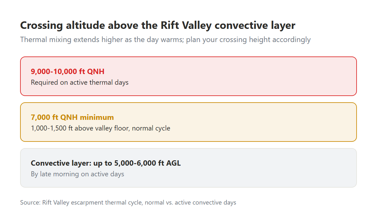
The practical mitigation is altitude. Flying the Naivasha basin at 7,000 ft QNH (approximately 1,000–1,500 ft above the valley floor) puts you above the convective mixing layer during normal thermal cycle periods. By late morning, thermals over dark ground can extend to 5,000–6,000 ft AGL on active days, which means you may need to be at 9,000-10,000 ft QNH to clear them, which in a C172 at high density altitude is close to or at service ceiling.
Wave activity above the escarpment
Mountain wave (standing wave formed in stable air above significant terrain) occurs when the atmosphere above the escarpment is stable and the wind is blowing at sufficient speed perpendicular to the ridge. Kenya does not experience the major mountain wave events common in the Alps or Rockies, but moderate wave activity above the escarpment is documented and has caused incidents.
Wave activity characteristics that are relevant to VFR pilots:
- Rotor zone: the turbulent circular flow beneath the wave crest, at or below the height of the generating terrain. This is the most dangerous part of a wave system and can be severe even when the wave itself is benign.
- Lenticular cloud: the lens-shaped cloud that forms at the crest of the wave. If you can see lenticular cloud sitting stationary over the escarpment, wave is active. Do not fly through or under lenticular cloud in a light aircraft without understanding exactly what the air is doing.
- Cap cloud: a cloud sitting directly on the escarpment ridgeline indicates moist, stable air being forced upward, and likely descending and becoming turbulent on the lee side.
The Suswa volcano area
Suswa volcano, in the southern Rift Valley west of Nairobi, creates its own local turbulence regime. The volcanic crater and surrounding collapsed caldera terrain generate strong thermals on warm days. Cross-country routes that pass south of Naivasha and track toward Magadi or the Masai Mara routinely cross the Suswa area. Student pilots on these routes for the first time are sometimes surprised by the turbulence intensity over terrain that looks benign on a topographic chart.
Practical routing strategies
Experienced Kenya pilots crossing the Rift Valley use several strategies to minimise turbulence exposure:
Time the crossing. Early morning (before 09:00 EAT) gives the best conditions. The thermal cycle has not yet developed, mechanical turbulence is lower with lighter surface winds, and the descent into the valley is made in stable air. The morning departure also provides a full day of reserve time if a diversion becomes necessary.
Gain altitude before reaching the escarpment. Climbing to the desired crossing altitude while still over the plateau (before reaching the escarpment) avoids the most turbulent zone directly above the ridge where mechanical uplift is strongest.
Cross perpendicular to the ridgeline. The longer you spend over the mechanical turbulence zone, the more you experience it. A direct crossing perpendicular to the escarpment minimises time in the turbulent area.
Use your POH turbulence penetration airspeed (Va). In significant turbulence, slow to the aircraft's manoeuvring speed (Va) immediately. For the C172, this is approximately 97 KIAS at gross weight. Flying above Va in turbulence risks structural damage: the gusts can impose load factors the aircraft is not designed for if you are above manoeuvring speed.
This should all be part of your weather decision-making process before any Rift Valley crossing. Document the turbulence risk and your mitigation strategy in your AngaBrief preflight assessment: your instructor will see it and either confirm your approach or suggest refinements before you depart.