Kenya is an unusual flying environment. The country's two busiest general aviation aerodromes, Wilson (HKNW) and Eldoret (HKEL), sit at 5,536 ft and 6,936 ft AMSL respectively. Nanyuki (HKNY) is at 6,250 ft. Kericho is at 6,710 ft. If you trained in the UK, Australia, or the United States at a coastal aerodrome and then arrived in Kenya, the aircraft you know will behave differently from your first day in the cockpit here.
The reason is density altitude. Understanding it thoroughly before you fly in the highlands is not optional.
What density altitude actually is
Pressure altitude is the altitude you read on your altimeter when set to 1013.25 hPa (standard pressure). Density altitude is pressure altitude corrected for non-standard temperature. It is the altitude at which the air behaves, from the aircraft's perspective, regardless of what your altimeter says.
The standard temperature lapse rate is 2°C per 1,000 ft. Standard temperature at sea level is 15°C. At Nanyuki's elevation of 6,250 ft, the International Standard Atmosphere (ISA) temperature would be 15 − (6.25 × 2) = 2.5°C. On a warm afternoon in Kenya, you might find 26°C on the ground at Nanyuki. That is an ISA deviation of +23.5°C.
The formula is: Density altitude = Pressure altitude + (120 × ISA deviation)
At Nanyuki with a pressure altitude of 6,250 ft and an ISA deviation of +23.5°C: density altitude = 6,250 + (120 × 23.5) = 6,250 + 2,820 = 9,070 ft. Your C172 is sitting on a 6,250 ft airstrip, but its engine, wings, and propeller think they are at 9,070 ft.
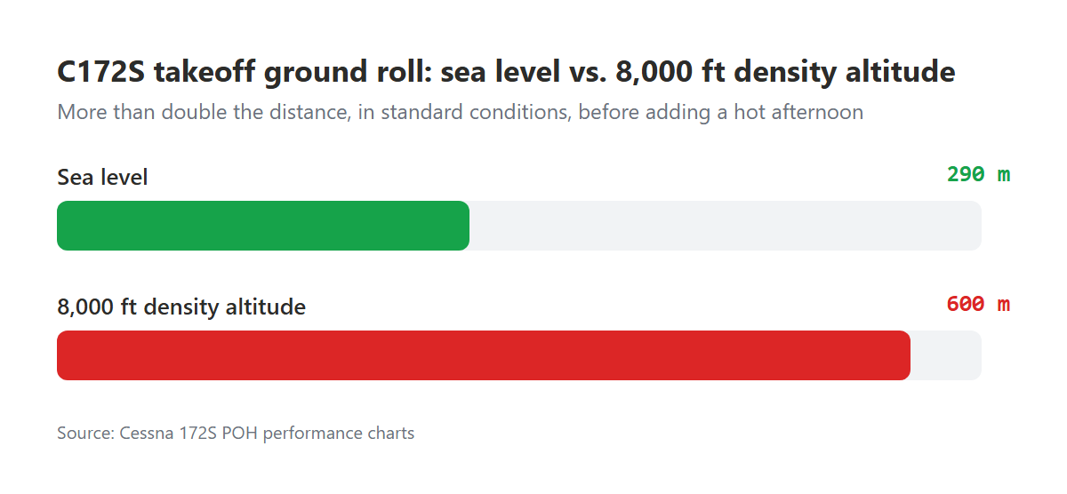
What high density altitude does to your aircraft
Every performance figure in your Pilot's Operating Handbook was calculated at specific conditions. When density altitude exceeds those conditions, performance degrades measurably.
Engine power. Normally aspirated piston engines produce power proportional to the mass of air they ingest. At high density altitude, the air is less dense: less mass per volume. A Lycoming O-320 in a C172 that produces 160 HP at sea level will produce significantly less at 9,000 ft density altitude. Roughly, you lose approximately 3% of power per 1,000 ft of density altitude above sea level. At 9,000 ft DA, you might have 75% of the rated power available at best.
Propeller efficiency. The propeller is an airscrew. It generates thrust by accelerating air rearward. At high density altitude, the same RPM moves less air mass, producing less thrust. This compounds the engine power reduction: both the engine and the propeller are degraded simultaneously.
Lift production. Lift = ½ρV²SCL. Rho (ρ) is air density. At higher density altitude, ρ is lower. To generate the same lift at the same angle of attack, the aircraft must fly faster. The aircraft's stall speed in true airspeed terms is higher. Your indicated airspeed will look normal (indicated airspeed is a pressure measurement), but your true airspeed is significantly higher.
Takeoff and landing roll. Because the aircraft needs to reach a higher true airspeed to lift off, and the engine is producing less thrust, the takeoff roll increases dramatically. The C172 POH charts show this clearly. At sea level on a standard day, takeoff ground roll for a C172S is approximately 290 m. At 8,000 ft density altitude, the same aircraft needs approximately 600 m or more: more than double, and that is in standard conditions, not a hot afternoon.
Nanyuki, Kericho, and the specific risks
Nanyuki (HKNY) has a runway of approximately 1,800 m, which sounds adequate until you account for the upslope at the northern end and the trees beyond the southern threshold. On a warm afternoon with a full load, a student C172 departing Nanyuki needs every metre.
Kericho (HKKE), at 6,710 ft AMSL and surrounded by tea plantations, has a significantly shorter usable runway. Cross-country students who have planned a fuel stop at Kericho sometimes discover, on the day, that the density altitude makes their planned load unacceptable. This is not an emergency. It is a planning failure that began with inadequate preflight performance calculation.
The critical errors that repeat:
- Using the sea level performance figures from the POH without correction for the departure aerodrome's elevation and the day's temperature
- Failing to account for the difference between early morning density altitude and afternoon density altitude at the same aerodrome (a 10°C temperature rise at Eldoret on a sunny day adds roughly 1,200 ft to your density altitude)
- Treating the highland runway length as adequate because it looked fine in satellite imagery, without calculating the actual accelerate-stop distance
How to calculate density altitude before every highland departure
The E6B flight computer has a density altitude scale. Most electronic flight planning apps include it. The steps:
- Obtain the current QNH from ATIS or the aerodrome operator.
- Convert QNH to pressure altitude: for every hPa below 1013, add 27 ft to field elevation. For every hPa above 1013, subtract 27 ft. This gives you pressure altitude.
- Obtain the current temperature at the aerodrome.
- Apply the ISA deviation formula: density altitude = pressure altitude + (120 × (temperature − ISA temperature at that altitude)).
- Go to the performance charts in your POH and read off the takeoff ground roll, accelerate-stop distance, and rate of climb at that density altitude.
Compare the calculated distances to the available runway length, with appropriate safety margins. A 50% margin on the takeoff ground roll is a reasonable starting point for a student pilot. If you do not have that margin, you do not depart until conditions improve.
When conditions improve
Density altitude is a function of temperature as well as elevation. In the Kenya highlands, temperature drops reliably at night and is lowest just before sunrise. A C172 that cannot safely depart Nanyuki at 14:00 on a warm afternoon may have adequate performance at 07:00 the following morning. This is not a theoretical consideration. It is a legitimate operational decision that experienced highland pilots make routinely.
Your PAVE pre-flight assessment should include a specific performance calculation for every departure from an aerodrome above 4,000 ft AMSL. If the calculation shows marginal or inadequate performance, that is an Environment risk flag, one that your instructor should be aware of when reviewing your assessment in AngaBrief.