The KCAA PPL syllabus requires student pilots to demonstrate navigation by pilotage and dead reckoning: map reading and calculated position estimation without electronic aids. This requirement exists because GPS, despite its near-universal availability, is not infallible. Antenna failures, battery depletion, software errors, and the occasional unfamiliar panel in a school aircraft all conspire to produce the situation every pilot should be able to manage: no GPS, no idea where you are, and terrain that looks largely the same in every direction.
In Kenya specifically, the challenge is real. The northern arid zones (routes toward Marsabit, Garissa, Lodwar, and Wajir) offer vast stretches of semi-desert and scrubland where visual landmarks are sparse and low-frequency ground navaids are limited. The highland routes, by contrast, are visually complex with valleys, ridges, and escarpments that look similar and are difficult to distinguish without careful chart correlation.
What pilotage actually is
Pilotage is navigating by visual reference to features on the ground: matching what you see outside the aircraft to what is shown on the chart. Done well, it is highly reliable. Done poorly, it is the precursor to geographical embarrassment or CFIT.
The keys to effective pilotage:
Pre-flight preparation. Mark your chart before you depart. Draw the track line. Identify checkpoints (prominent features that are visible from the air) approximately every 10–15 minutes of flying time. For Kenya routes, useful checkpoints include lakes (Naivasha, Elementaita, Nakuru, Baringo), escarpment features (the Rift Valley edge is highly distinctive from the air), major roads (the Nairobi-Nakuru highway, the Mombasa road), rivers (seasonal in the north but distinctive when flowing), and mountains (Longonot, Suswa, Kenya, Kilimanjaro on clear days to the south).
Time management. Know when you expect to see each checkpoint. If a checkpoint does not appear within two minutes of its expected time, do not assume you are on track. Begin a formal position fix attempt.
Looking broadly. Student pilots often look for a specific feature ("the river") and miss it because they are expecting it at the wrong scale or position. Train yourself to look broadly at the terrain picture first, then match it to the chart, rather than hunting for a specific feature.
Dead reckoning: the mental arithmetic of navigation
Dead reckoning is the calculation of your current position based on a known starting point, a measured elapsed time, a measured heading, and an estimated true airspeed corrected for wind effect. No visual reference is required: it is entirely a matter of keeping the calculation current.
The dead reckoning cycle:
- Note your last confirmed position and the time you were there
- Note your current indicated heading (correct for compass deviation using the deviation card)
- Note your airspeed
- Apply the forecast wind (direction and speed) to calculate your track and groundspeed
- Apply elapsed time to groundspeed to calculate distance travelled from last confirmed position
- Plot that distance along the calculated track to find estimated position
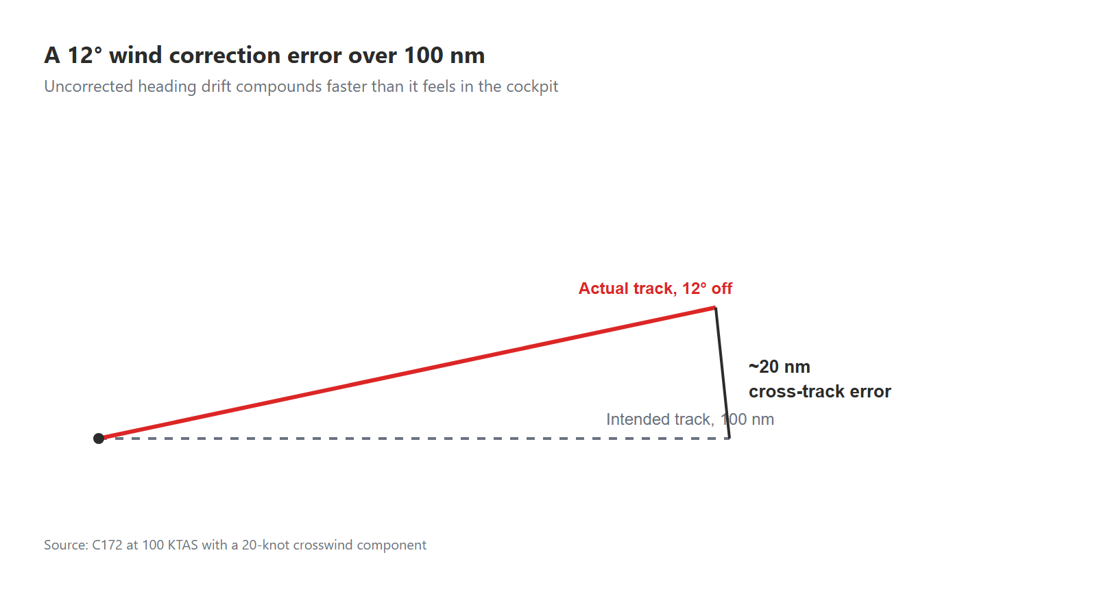
In a C172 at 100 KTAS with a 20-knot crosswind, the wind correction angle (WCA) is approximately 12°: a meaningful deviation from heading to track. A student who is flying the heading without applying the WCA will be off track by 12° of arc, which over a 100 nm sector produces approximately 20 nm of cross-track error. At that error, you will not recognise the terrain you are flying over, and it will happen faster than you expect.
The northern Kenya scenario: Nairobi to Wajir
The 500 nm route from Wilson to Wajir (HKWJ) takes a C172 over approximately five hours of mostly semi-arid terrain, crossing the Tana River, the Ewaso Nyiro basin, and several hundred kilometres of bush country where roads are sparse and villages are not individually identifiable from the air.
On this route, pilotage is supported primarily by terrain macro-features rather than the specific landmarks available on highland routes. The Tana River is visible at any season: it is the primary east-west drainage of the northern slope of Mount Kenya and the Aberdares, and it shows clearly on the chart and on the ground. The Ewaso Nyiro River serves the same function for the route north of Isiolo. These are your progress checkpoints: reach them at the expected time and on the expected heading, and you are on track.
The skill is to know, before you depart, exactly where you expect to cross each river, what the crossing heading implies about your track versus your heading, and what the timing should be. Practice this planning on the chart before the sortie, not in the cockpit while flying.
When you are lost: the systematic fix
Every student pilot has been taught the DECIDE model or similar decision frameworks for emergencies. Realising you do not know your position is not quite an emergency: it is a navigation error that requires a structured response, not a panic response.
The systematic fix procedure:
- Maintain control of the aircraft. Do not let navigation anxiety distract you from flying the aircraft. Establish level flight at a safe altitude, set a power setting for cruise, and note the time.
- Identify the last confirmed position. When did you last know where you were? What was your heading and airspeed since then? Calculate your estimated position using dead reckoning from that point.
- Look for broad confirmatory features. Do you see a lake, a major escarpment, a large river? Match the broad picture to the chart around your estimated position.
- Climb if safe. Greater altitude improves the range of visual reference and may restore radio and GPS contact. In Kenya's terrain, climbing also improves terrain clearance if you are uncertain of your actual position.
- Use available navigation aids. NDBs at HKJK and other major aerodromes are usable over much of Kenya. A single NDB bearing, combined with your dead reckoning estimate, narrows your position significantly.
- Declare uncertainty to ATC. A call to Nairobi Approach or any available frequency (even a position UNSURE transmission) gets you assistance. There is no certificate-level consequence for admitting navigation uncertainty. There is a very significant safety consequence for not admitting it.
Building the skill before you need it
The students who manage GPS-absent scenarios well are those who have practised navigating without it regularly: not as a one-off emergency exercise but as routine practice. Ask your instructor for sessions where the GPS is covered and you navigate the exercise entirely by pilotage and dead reckoning. The discomfort of managing uncertainty on those sessions is far more productive than the false confidence of always knowing your GPS position.
Your PAVE assessment for any cross-country flight should include navigation planning in the Environment category: specifically, what are your checkpoints, what are your timing expectations, and what is your plan if you cannot confirm position at any point. This planning should be documented, not mental. Documented plans survive the cognitive load of actual flight better than mental ones.